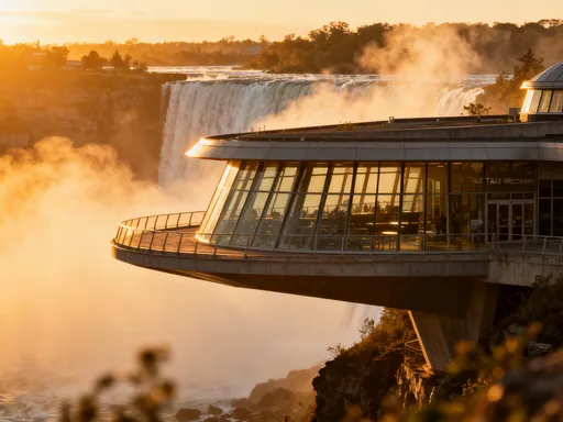
Nairobi's Wild Terrain Secrets You've Never Seen
You know that feeling when you think you’ve seen it all, and then Nairobi hits you with something totally unexpected? Yeah, me too. I went in chasing safaris and city vibes, but what blew my mind was the wild, rugged terrain hiding in plain sight—ancient volcanic ridges, sprawling escarpments, and urban forests clinging to cliffs. This isn’t just a city; it’s a geological rollercoaster. Let me take you deep into the landscapes most travelers completely miss. Beneath Nairobi’s modern surface lies a story written in stone, shaped by fire and time, where the earth cracked open and mountains rose from chaos. This is not merely a backdrop to daily life—it is the foundation of the city’s soul, a silent architect of its neighborhoods, ecosystems, and identity. And once you learn to read it, the ground beneath your feet becomes a living map of history.
The Rift Valley’s Hidden Backbone
Nairobi’s dramatic topography is no accident. It is the direct result of its location on the eastern edge of the Great Rift Valley, one of the most significant geological features on Earth. This immense tectonic trench stretches over 6,000 kilometers from Syria to Mozambique, formed by the gradual separation of the African and Somali tectonic plates. Nairobi sits just above the western shoulder of this rift system, where the earth’s crust has been stretched, fractured, and uplifted over millions of years. Satellite imagery reveals a clear lineament running southwest from the city—a visible scar of ancient faulting that continues to shape the landscape today.
The most striking evidence of this tectonic drama appears in the form of steep escarpments and elevated ridges on the city’s outskirts. Areas like Karen and Lang’ata are built along these uplifted zones, where homes perch on rolling hills that drop sharply into broad, dry valleys. These are not random hills—they are fault-block formations, raised segments of crust lifted by subsurface forces. The contrast between the highland neighborhoods and the lower plains beyond is not just scenic; it is a direct reflection of the ongoing geological activity beneath the surface. Elevation shifts of hundreds of meters occur within just a few kilometers, creating sudden changes in climate, vegetation, and drainage patterns.
What makes this geological foundation so compelling for travelers is how visibly it shapes the city’s character. The Rift Valley’s influence means Nairobi is not flat or predictable. It is a city of sudden ascents and descents, where roads twist along ridgelines and valleys open without warning. This terrain has guided urban development, dictated water flow, and created micro-environments that support diverse plant and animal life. Understanding this hidden backbone allows visitors to appreciate Nairobi not just as a modern African capital, but as a city born from elemental forces—where every hillside tells a story of deep time and tectonic transformation.
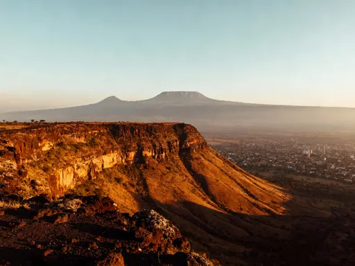
Ngong Hills: Where Nature Meets the Fault Line
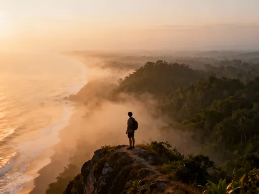
Rising like sentinels to the southwest of Nairobi, the Ngong Hills are one of the most iconic yet underappreciated geological features in the region. Comprised of four main peaks—Longonot, Ol Donyo Orok, Ol Donyo Esikima, and Ngong Ridge—these hills were formed by volcanic activity and tectonic rifting that occurred between 15 and 5 million years ago. Their distinct, elongated shape follows the alignment of fault lines in the Rift Valley system, making them a textbook example of horst formation—blocks of land uplifted between parallel faults. From above, satellite views show a sharp linear ridge cutting across the landscape, a clear signature of the earth’s crust being pulled apart.
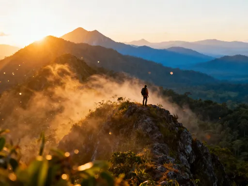
Hiking the Ngong Hills offers more than just exercise—it’s a journey through layered geology and shifting ecosystems. The trails wind over weathered volcanic rock, some surfaces smoothed by millennia of wind and rain, others jagged with basalt outcrops. As you climb, the elevation gain—reaching over 2,400 meters at the highest point—brings noticeable changes in temperature and air clarity. At the summit, the panoramic view stretches across the Rift Valley floor, where shimmering salt flats and distant hills create a vast, almost lunar landscape. On clear mornings, you can see the silhouette of Mount Longonot and the Aberdare Range in the distance, framed by the curvature of the earth.
But the Ngong Hills are more than just a geological wonder. They hold deep cultural significance for the Maasai people, for whom the hills—known as Oloolaiser, meaning “the place of drying hides”—have long served as landmarks, spiritual sites, and grazing boundaries. Today, conservation efforts by local communities and environmental groups help protect the native grasslands and acacia woodlands from encroachment and illegal logging. Visitors are encouraged to follow marked trails, avoid littering, and respect sacred areas. The best time to hike is early morning or late afternoon, when temperatures are mild and the light enhances the texture of the rock and soil. With proper preparation—sturdy shoes, water, and sun protection—this experience offers a rare chance to walk atop a tectonic rift, where the earth’s power is both visible and palpable.
Urban Cliffs and Hidden Gorges
Within Nairobi’s bustling urban fabric lie surprising remnants of its wild geological past—rocky cliffs, fault-line gorges, and exposed ridges that have survived decades of development. These features are most evident in green spaces like City Park and along the edges of Karura Forest, where ancient rock formations rise abruptly from paved roads and residential zones. In City Park, a series of low but distinct ridges runs through the heart of the reserve, their slopes covered in indigenous trees and ferns. These are not artificial landscaping—they are natural fault scarps, formed when blocks of earth shifted and cracked during tectonic activity. Walking along the trails here, you can see where the soil has eroded, revealing layers of weathered basalt and sedimentary deposits.
Even more dramatic are the hidden gorges near Karura Forest, where seasonal streams have carved deep channels into the volcanic rock over thousands of years. One such ravine, accessible via a footbridge near the forest’s eastern entrance, drops several meters below the surrounding land, creating a cool, shaded microclimate that supports mosses, ferns, and birdlife. These gorges follow the path of ancient fractures in the earth, now softened by vegetation but still clearly aligned with regional fault patterns. The contrast is striking: just meters away, traffic hums along Thika Road, yet here, the sound of flowing water and rustling leaves dominates.
What makes these urban geological features so valuable is their role as natural refuges within the city. They provide habitat for wildlife, regulate local temperatures, and offer residents a direct connection to Nairobi’s pre-urban landscape. Trail systems in these areas are carefully designed to follow the natural contours of the land, allowing visitors to experience elevation changes and rock formations without disrupting the ecosystem. Educational signage explains the origins of the cliffs and gorges, helping to foster awareness of the city’s geological heritage. For the observant traveler, these sites offer a quiet revelation: that nature did not retreat from Nairobi—it was built around it, and in places, it still asserts its presence with quiet strength.
Karura Forest: A Geological Sanctuary
Spanning 270 acres in the northern part of the city, Karura Forest is more than a green lung for Nairobi—it is a protected geological sanctuary shaped by water, time, and tectonic forces. At its heart flows the Karura River, a tributary of the larger Nairobi River system, which has spent millennia cutting through layers of ancient basalt and volcanic ash. The result is a network of deep, stream-carved ravines and exposed rock faces that reveal the area’s volcanic origins. Along the forest’s main trails, visitors cross wooden bridges suspended over narrow gorges, where the sound of rushing water echoes against sheer rock walls. These formations are not just scenic—they are evidence of persistent fluvial erosion, a slow but powerful force that continues to shape the terrain.
The forest’s topography supports a rich diversity of life. The shaded ravines create cool, moist environments ideal for ferns, mosses, and epiphytic plants, while the sunlit ridges host acacia, euphorbia, and wild olive trees. This variation in microhabitats is directly tied to the underlying geology: the porous basalt rock allows for good drainage, preventing waterlogging and supporting deep-rooted vegetation. In some areas, the rock is visibly fractured, with joints and fissures that guide the flow of water and root systems alike. These geological features also contribute to the forest’s tranquility—sound is absorbed by the rock and vegetation, creating pockets of near-silence even on busy weekends.
Karura Forest stands as a model of how urban planning can coexist with natural terrain. Once threatened by illegal development and deforestation, it was saved through community-led conservation efforts in the 1990s, led by environmentalist Wangari Maathai. Today, it offers well-maintained trails that respect the land’s contours, avoiding unnecessary grading or blasting. Visitors can walk along cliffside paths, descend into gullies, and pause at observation points that highlight both the beauty and fragility of the landscape. The forest is not just a place to escape the city—it is a place to understand it, to see how water, rock, and time have combined to create a sanctuary in the midst of urban sprawl.
Lava Landscapes Beyond the City
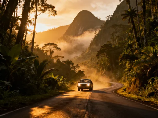
East of Nairobi, beyond the congestion of Embakasi and Kitengela, the land tells a different geological story—one of fire and flow. The regions around Juja and Thika are built upon ancient lava fields, remnants of volcanic eruptions that occurred millions of years ago during intense tectonic activity in the Rift Valley. These flows, now solidified into dark, dense basalt rock, created a gently undulating plain that contrasts sharply with the steep ridges near the Rift’s edge. From the air, the landscape appears as a mosaic of rocky outcrops, agricultural plots, and patches of regenerating forest, all sitting atop a foundation of cooled magma.
While these lava fields were once barren and inhospitable, time and weathering have transformed them into fertile ground. The slow breakdown of basalt releases essential minerals like iron, magnesium, and potassium into the soil, creating conditions ideal for farming. Today, the area supports large-scale horticulture, including flower farms, vegetable cultivation, and tree nurseries. The terrain influences drainage patterns, with water collecting in natural depressions between lava flows, forming seasonal wetlands that sustain birds and insects. In some places, the original surface of the lava is still visible—ropy textures known as pahoehoe and blocky aa flows that geologists use to interpret the speed and temperature of the ancient eruptions.
For travelers, these landscapes offer a chance to see how geology directly shapes livelihoods. Guided farm tours often include stops at exposed rock faces, where guides explain the connection between soil quality and volcanic history. The rolling hills and rocky outcrops also provide scenic backdrops for picnics, birdwatching, and photography. While not as dramatic as the Rift Valley escarpments, these lava plains are a quiet testament to the transformative power of nature—where once-dangerous flows now nourish the land and support communities. Understanding this history deepens appreciation for the region’s agricultural abundance and the resilience of life in the face of geological change.
How Terrain Shapes Nairobi’s Identity
The influence of Nairobi’s terrain extends far beyond scenery—it is woven into the city’s social, cultural, and infrastructural fabric. Elevation differences dictate everything from neighborhood prestige to drainage efficiency. Areas like Lavington, Gigiri, and Muthaiga sit on higher ground, historically favored for their cooler temperatures, cleaner air, and panoramic views. These elevations were not chosen at random; they follow the natural ridges formed by tectonic uplift, making them less prone to flooding and more accessible to fresh groundwater. In contrast, low-lying zones like Eastlands and parts of Embakasi have long struggled with waterlogging and informal settlements, challenges directly linked to their position in the topographic gradient.
Transportation routes, too, reflect the constraints of the land. Major roads like Ngong Road and Thika Superhighway follow the path of least resistance, weaving around hills and gorges rather than cutting straight through. This creates a city that feels organic rather than grid-like, with routes that curve and climb in response to the terrain. Public transit systems must account for steep gradients, influencing bus routes and the placement of stations. Even water and sewage systems are designed with elevation in mind, relying on gravity to move fluids through the city.
Perhaps most significantly, the terrain has shaped Nairobi’s green spaces. Urban planners have preserved ridges, forests, and river valleys not just for recreation, but because they serve as natural buffers against erosion and flooding. The city’s commitment to maintaining Karura Forest, City Park, and the Ngong Road Green Belt is as much about geology as it is about conservation. These areas stabilize the soil, reduce runoff, and protect the delicate balance between urban development and natural systems. In this way, Nairobi’s identity is not just defined by its people or economy, but by the very ground it stands on—a dynamic, living landscape that continues to shape the rhythm of daily life.
Traveler’s Guide to Experiencing the Terrain
To truly appreciate Nairobi’s geological wonders, travelers should plan intentional outings that focus on terrain awareness. Start with the Ngong Hills for a full-day hike, arriving by 6:30 a.m. to avoid heat and crowds. Wear trail shoes with good grip, bring at least two liters of water, and pack a light snack. Use the free Google Earth or PeakVisor app to identify geological features in real time—these tools overlay topographic data and peak names, helping you interpret the landscape as you walk. For a gentler experience, visit Karura Forest’s eastern trail, where the river gorge and basalt exposures are easily accessible via paved and gravel paths. The forest is open daily from 6 a.m. to 6 p.m., and guided walks are available on weekends through the Friends of Karura Forest initiative.
For those interested in urban geology, a self-guided drive along Lang’ata Road offers excellent views of the Rift Valley escarpment. Stop at designated viewpoints to observe fault lines and layered rock formations. City Park, near the Bomas of Kenya, is another accessible spot, with interpretive signs explaining the ridge systems. Photography enthusiasts will find the best light during the golden hours—just after sunrise and before sunset—when shadows accentuate the texture of cliffs and gorges.
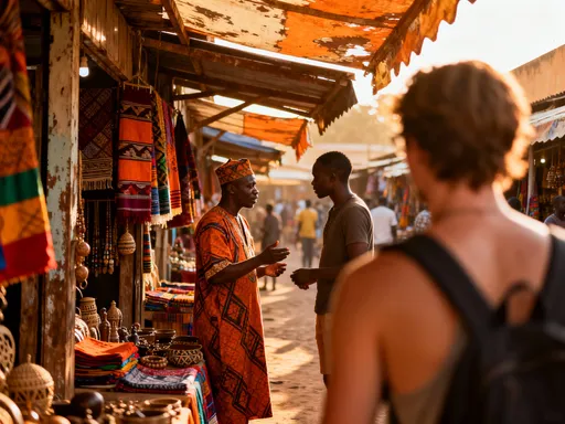
When exploring, always practice responsible tourism. Stay on marked trails to prevent erosion, avoid removing rocks or plants, and carry out all waste. Support local cafés and cultural centers near these sites—places like the Karen Blixen Coffee Garden or the Karura Forest Eco-Centre—to contribute to community-based conservation. Most importantly, take time to look down. While safaris and markets draw most attention, the real story of Nairobi begins beneath your feet, in the ancient rock, the silent faults, and the slow, persistent work of water and time. By engaging with this hidden layer, travelers gain a deeper, more meaningful connection to one of Africa’s most dynamic cities.
In the end, Nairobi is not just a gateway to the savannah or a hub of modern African life. It is a city built on movement—on the slow, unstoppable shift of tectonic plates, the cooling of lava flows, and the patient carving of rivers. Its hills, cliffs, and gorges are not obstacles to development, but the very foundation of its beauty and resilience. To visit Nairobi and only see its wildlife or culture is to miss half the story. The true wonder lies in understanding that every step you take is on ground shaped by forces older than memory, where the earth itself tells a tale of fire, fracture, and renewal. So next time you’re here, pause. Look around. And then look down. The terrain is waiting to speak—if you’re willing to listen.